The site
Geographical location
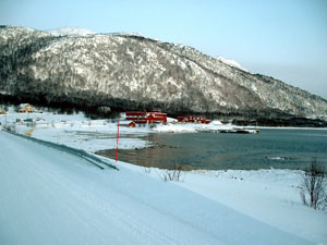
The site is located in the municipality of Tranøy, on the island of Sejna in Troms county. The island has a bridge connection to the mainland in the neighbouring municipality of Lenvik. Coastal route 860 runs immediately adjacent to the facility and the nearest town is Stonglandseidet (about 20 km. away), which is where the staff live.
Water source
 The facility can draw both freshwater and seawater.
The freshwater source is the small lake of Litjevatnet and the main inlet pipe runs directly from the lake at 62 masl (meters above sea level) to the facility at 3 masl.
For periods of low source water levels, a siphoning pipe is installed further up the waterway.
This siphon transfers water from the larger lake Langevannet (285 masl) to the lake Storelvvannet (245 masl) which in turn directly supplies Litjevatnet via connecting creeks.
The facility can draw both freshwater and seawater.
The freshwater source is the small lake of Litjevatnet and the main inlet pipe runs directly from the lake at 62 masl (meters above sea level) to the facility at 3 masl.
For periods of low source water levels, a siphoning pipe is installed further up the waterway.
This siphon transfers water from the larger lake Langevannet (285 masl) to the lake Storelvvannet (245 masl) which in turn directly supplies Litjevatnet via connecting creeks.
The facility has some ability to regulate the water level in Litjevatnet (down to ~20 cm below normal), which dries the affluent creek during periods of low rainfall. The impact of this is not of concern as there is no naturally occuring trout or charr in the water way, nor is it a spawning creek for anadromous salmon. The larger Langevannet however has a relatively large reservoir capacity and the facility has permission to draw up to 20 cm.
The sea water is drawn from a depth of 10 m. but is not used as culture water. It is instead used to exchange heat with the source water in order to raise temperature in the outside tanks by a few degrees (especially during winter).
Water temp. and quality
The source water temperature can fall as low as under 1°C during the winter and reach above 15°C during the summer depending on which lake depth the water is drawn from.
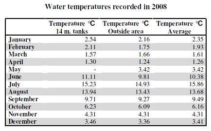
The below table shows the recorded 2008 temperatures in the outside area tanks and large 14 m. tanks.
 The facility comissioned NIVA (Norwegian Institute of Water Research) to conduct survey to document the water quality at the site.
The measured parameters and figures below are from a survey conducted in 2006.
The facility comissioned NIVA (Norwegian Institute of Water Research) to conduct survey to document the water quality at the site.
The measured parameters and figures below are from a survey conducted in 2006.
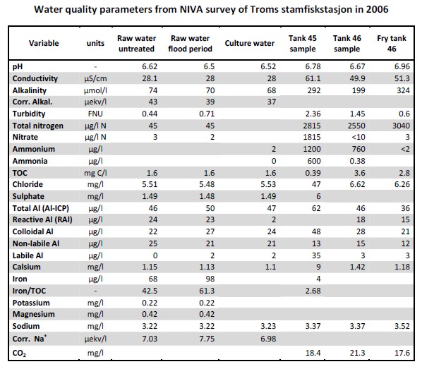 One point of concern was somewhat high levels of gill iron accumulation, which could be remedied by additional aeration (to precipitate as iron oxide) before distribution to the tanks.
High in-tank CO2 levels were also pointed out with a recommendation of increased in-tank aeration, greater water exchange or lower biomass.
One point of concern was somewhat high levels of gill iron accumulation, which could be remedied by additional aeration (to precipitate as iron oxide) before distribution to the tanks.
High in-tank CO2 levels were also pointed out with a recommendation of increased in-tank aeration, greater water exchange or lower biomass.
Effluent water
 The depth of the bay on which the facility is located slopes off very gradually, reaching 5 m. depth after approximately 100 m. from the shoreline.
The effluent outlet pipe extends 400 m. into the bay to reach a depth of 30 m. Since the seawater intake line and the main outlet are separated by 20 m. of depth and the outlet is placed down-current, there is not thought to be any effluent contamination of the intake line.
At the current production rate, there is negigable effect on the bay's ability to absorb the effluent nutrients. The effluent is passed through a 100 μm mesh drum filter to separate out the larger waste particles before discharge into the outlet pipe.
Weather and climate
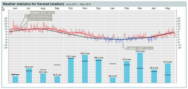
The climate of the site is illustrated in the below temperature and precipitation chart.
The black line represents normal temperature, the blue and red bars represent recorded temperature points, the red/blue line is the smoothed temperature curve and the blue columns represent recorded monthly precipitation.
Infrastructure
 The facility has good access to local infrastructure, with county route 860 running directly past the facility.
The nearest population center is in the neighbouring municipality of Lenvik approximately 40 km. away.
The facility has good access to local infrastructure, with county route 860 running directly past the facility.
The nearest population center is in the neighbouring municipality of Lenvik approximately 40 km. away.
The facility is situated on the shoreline where a small breakwater and dock has been built. There is however limited depth at the dock (>3 m. at low tide) which limits the size of vessels that can dock here. Electrical power is provided through the municipal grid.