The site
Geographical location
Malawi is a landlocked country in southeastern Africa, bordered by
Zambia to the northwest, Tanzania to the northeast and Mozambique to
the south, southwest and southeast. It lies between latitudes 9° and
18°S, and longitudes 32° and 36°E.
The Great Rift Valley runs through the country from north to south, and to the east of the valley lies Lake Malawi (also called Lake Nyasa), making up over three-quarters of Malawi's eastern boundary. Lake Malawi is sometimes called the Calendar Lake as it is about 587 km long and 84 km wide. The Shire River flows from the south end of the lake and joins the Zambezi River 400 kilometers farther south in Mozambique. The surface of Lake Malawi is located at 457 m above sea level, with a maximum depth of 701 metres (2,300 ft), which means the lake bottom is over 213 m below sea level at some points.
Lake Malawi has for millennia provided a major food source to the residents of its shores since its waters are rich in fish. Among the most popular are the four species of chambo, consisting of any one of four species in the subgenus Nyasalapia (Oreochromis karongae, O. lidole, O. saka and O. squamipinnis), as well as the closely related O. shiranus.
 Other
species that support important fisheries include the Lake Malawi
sardine (Engraulicypris sardella) and the large kampango catfish (Bagrus
meridionalis). Most fishing provides food for the increasing human
population near the lake, but some are exported from Malawi. The
wild population of fish is increasingly threatened by overfishing
and water pollution. A drop in the lake's water level represents
another threat, and is believed to be driven by water extraction by
the increasing human population, climate change and deforestation.
Other
species that support important fisheries include the Lake Malawi
sardine (Engraulicypris sardella) and the large kampango catfish (Bagrus
meridionalis). Most fishing provides food for the increasing human
population near the lake, but some are exported from Malawi. The
wild population of fish is increasingly threatened by overfishing
and water pollution. A drop in the lake's water level represents
another threat, and is believed to be driven by water extraction by
the increasing human population, climate change and deforestation.
The chambo and kampango have been particularly overfished (the kampango declined by about 90% from 2006 to 2016, O. karongae and O. squamipinnis by about 94%, and O. lidole might already be extinct and they are now seriously threatened. The IUCN recognizes 117 species of Malawi cichlids as threatened; some of these have tiny ranges and may be restricted to rocky coastlines only a few hundred meters long.
The University of Lilongwe (LUANAR) with the department of fisheries and aquaculture is running a farm which which was previously a financial drain on the College and thus Bunda Farm was commercialised in May 2005 and is now formally a limited liability company. The Bunda Campus farm site is located close to the Bunda Campus, (Google plus code: RQCH+58 Mwenda). The solar powered hatchery was established at the Bund Campus farm in order to provide a template and a node for training for Malawian farmers.
Water source
 The Bunda
farm is located at a lake which ensures good quality water around
the year to feed properly all the ponds at the site. The Bunda fish
hatchery uses two sources of water; groundwater extracted from the
ground using a pump, and Bunda water reservoir. The water from the
reservoir passes through the bio filters as it is suspected not to
be free from pathogens and some toxic pollutants. The groundwater
does not pass through the bio filters basing on the fact that it is
normally free from pathogens and also other pollutants. Water supply
for the hatchery can be drawn from a deep and a shallow well.
The Bunda
farm is located at a lake which ensures good quality water around
the year to feed properly all the ponds at the site. The Bunda fish
hatchery uses two sources of water; groundwater extracted from the
ground using a pump, and Bunda water reservoir. The water from the
reservoir passes through the bio filters as it is suspected not to
be free from pathogens and some toxic pollutants. The groundwater
does not pass through the bio filters basing on the fact that it is
normally free from pathogens and also other pollutants. Water supply
for the hatchery can be drawn from a deep and a shallow well.
Water temperature and quality
The well water comes up with a temperature of about 18C°. The groundwater has a very good quality, although one point of concern was somewhat high levels of calcium carbonate concentration in the water from the deep well which can cause some problems with technical equipment's such as pumps. Preferably water from the shallow well is being used for the hatchery operation. Analyses of the well water showed that pH ranged from 7.8 in the pumping point to 8.0 in the hatchery. Whilst alkalinity ranged from 96.33mg/L to 96.39 mg/L. Furthermore, the readings for ammonia ranged 0.013 mg/L to 0.014 mg/L.
Effluent water
 A
tilapia hatchery like those at the Bunda campus farm
has naturally a very small amount of discharge water. The discharge water
which becomes available when e.g. the water is changed in the larval
tanks is being used to irrigate plant crops at the farm. Thus, the
ammonium excreted from the fish is being used as a fertilizer.
A
tilapia hatchery like those at the Bunda campus farm
has naturally a very small amount of discharge water. The discharge water
which becomes available when e.g. the water is changed in the larval
tanks is being used to irrigate plant crops at the farm. Thus, the
ammonium excreted from the fish is being used as a fertilizer.
Weather and climate
Malawi has a sub-tropical climate, which is relatively dry and
strongly seasonal. The warm-wet season stretches from November to
April, during which 95% of the annual precipitation takes place.
Annual average rainfall varies from 725mm to 2,500mm with Lilongwe
having an average of 900mm, Blantyre 1,127mm, Mzuzu 1,289mm and
Zomba 1,433mm. Extreme conditions include the drought that occurred
in 1991/92 season and floods of 1988/89 season. The low-lying areas
such as Lower Shire Valley and some localities in Salima and Karonga
are more vulnerable to floods than higher grounds. A cool, dry
winter season is evident from May to August with mean temperatures
varying between 17 and 27 degrees Celsius, with temperatures falling
between 4 and 10 degrees Celsius. In addition, frost may occur in
isolated areas in June and July. A hot, dry season lasts from
September to October with average temperatures varying between 25
and 37 degrees Celsius. Humidity ranges from 50% to 87% for the
drier months of September/October and wetter months of
January/February respectively.
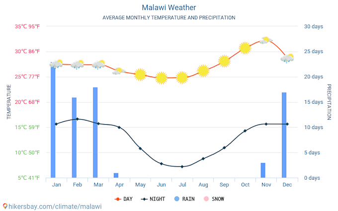 The map depicts average monthly temperatures and weather, sunny and cloudy days and the annual rainfall in Malawi as mean values from 2015 - 2019.
Infrastructure
The facility has good access to local infrastructure, and is
accessible by car in about 15 min from the Bunda Campus. Electrical power is
provided through the public grid, which, however frequently fails to
provide electricity. This is the reason, why the tilapia hatchery
was
equipped with a solar power facility (see for details the chapter
facility and equipment).
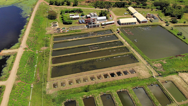 The picture shows an aerial view from the farm area (taken with a
drone), with the lake which provides the water for the ponds on the
left side, even in the dry season.
The picture shows an aerial view from the farm area (taken with a
drone), with the lake which provides the water for the ponds on the
left side, even in the dry season.